Important Notice: Greer Fire Updates.
Our facily remains open and accepting all patients
Upade 10:00 AM, May 26, 2025
The Greer fire is at 100% containment as of 05/26/2025
Update 10:30 AM, May 22, 2025
Fire containment is at 88%
Zones remain in "SET" Please reference the interactive map below
A link tree has been established for the greer fire for various updates:
Greer Fire 2025 link tree
Update - 6:15 PM, May 19, 2025
Areas previously under "GO" have been downgraded to "SET". For a more accurate map, please reference the interactive map that has been embedded below.
Authorities have authorized a phased re-entry for evacuated communities.
To view the official Press Release from the Apache County Emergency Management and Preparedness, click here.
Update - 9:30 AM, May 19, 2025
Our facility remains open and accepting all patients.
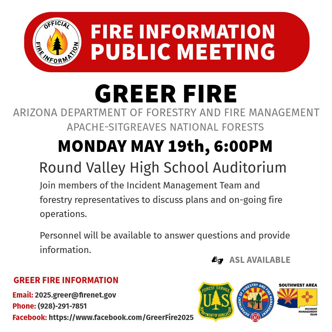
Update - 7:30 AM, May 19, 2025
There have been no new SET or GO orders. Reference the interactive map for current orders. A community meeting will be held tonight, 5/19/2025 at 6 PM at the high school. The flyer is below
Update - 7:30 PM, May 16, 2025
A live evacuation zones & fire map has been created for community members by the Southwest Incident Command
Update - 1:45 PM, May 15, 2025
Southwest Area Incident Management Team 3 has created a Phone number for real-time information
Operational update by Southwest Area Incident Management Team 3
https://www.facebook.com/share/v/1Fs4MNcQVh/
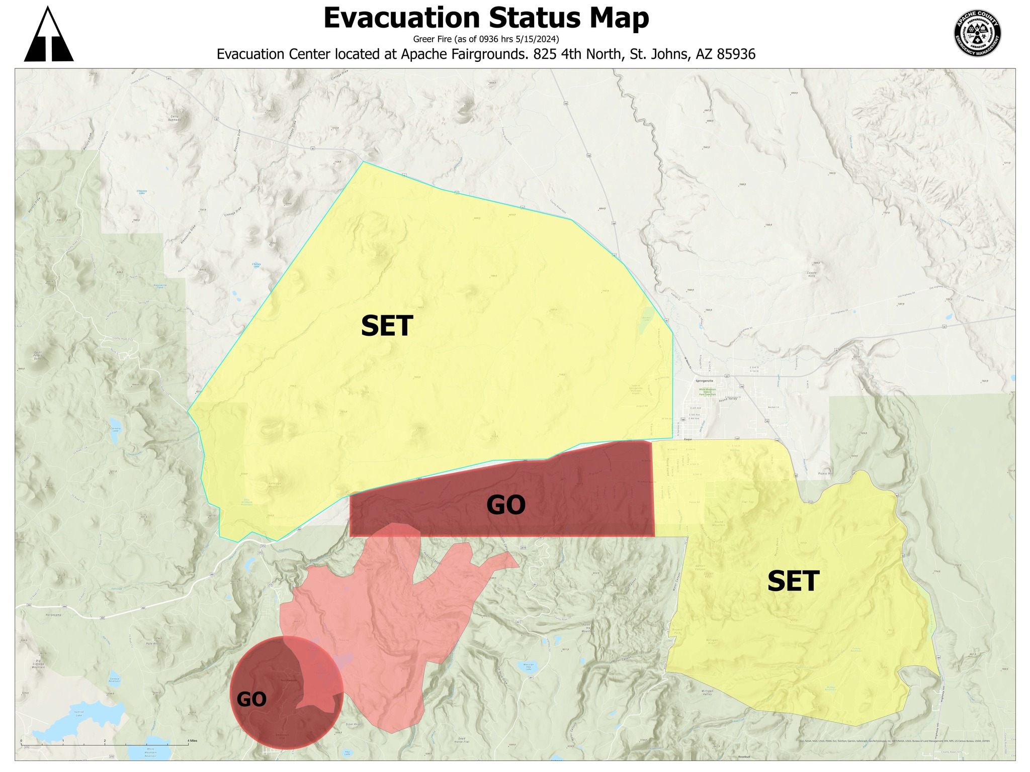
Update - 9:30 AM, May 15, 2025
ALERT: All areas north of SR 260 and west of Burk Road have been moved to SET. This also includes the area west of US-191 in Springerville Arizona. Please be prepared in the event of evacuations.
ALERT: All areas south of SR 260, Forest Service Road 85 and between Water Canyon Road and US 191/180 are put on SET. Please be prepared in the event of evacuations.
Update - 2:45 PM, May 14, 2025
ALERT: All Eagar residents who are south of State Route 260 and between River Road and the SR260/180 junction have been moved to SET. Please prepare in the event you are evacuated.

Update - 2:15 PM, May 14, 2025
EMERGENCY: Due to wildfire threat, any residents south of HWY 260 and West of River Road have been moved to GO! EVACUATE NOW! Updates will be provided on 311info.net
Update - 1:45 PM, May 14, 2025
Please practice smoke safety precautions.
The fire is now at 6,400 acres. It continues to move to the north/northeast The fire has moved through Hobson Canyon and is pushing onto State Trust lands at the head of the fire. SR 261 is now closed from SR 260 to the Point of Mountain.
https://inciweb.wildfire.gov/incident-information/aza2s-greer-fire
Update - 10:45 AM, May 14, 2025
Please see below for a open letter to the community from our CEO
Community Letter
Update - 9:45 AM, May 14, 2025
Per the Apache County Office of Emergency Management, Multiple areas are in GO with some in SET.
GO: Greer, South Fork, and residents west of Highway 261
SET: River Road in Eagar west to Highway 261
A shelter is open in St. Johns at the County Fairgrounds. The fairgrounds has the capacity to house small and large animals.
Highway 260 is closed in both directions near Greer. For updated travel information: az511.com
Update - 7:15 PM, May 13, 2025
Evacuation location has been switched from The Round Valley Dome to Saint Johns BUB at the Fairgrounds.
Update - 5:30 PM, May 13, 2025
Set - Level 2 - Evacuation Warning
Update - 4:00 PM, May 13, 2025
If you have not done so already you can sign up for the Apache County Emergency Management and Preparedness Text allert system by going to this link: https://www.smart911.com/smart911/registration/registrationLanding.action
Update - 2:28 PM, May 13, 2025
Law Enforcement in Eagar, AZ is going door to door to notify residents they are put on SET in the 26 Bar neighborhood. This DOES NOT mean they are being evacuated. If the 26 Bar area is put on GO for Evacauations, we will put a notification out.
Apache County Shierrifs Office is in command of all evacuation. If there is a change in evacuation status, ACSO will notify residents alongside Round Valley Police.
Update – 2:00 PM, May 13, 2025
All citizens of Greer and north woods and south fork are on evacuation order.
Everyone east of south fork and east of 261 within a 1 mile radius is on set
Evacuation sites have been established as the:
RV Dome
Alpine Community Center
RVs and animals go to the Round Valley Rodeo Grounds
Initial Up:date – 12:45 PM, May 13, 2025
**Greer Fire Evacuation Information**
All of Greer is now being evacuated including North Woods and South Fork.
The situation is being monitored by the Northeastern Arizona Public Information System.